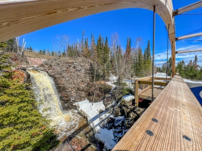
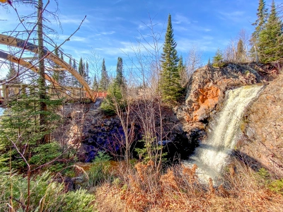
On the outskirts of Grand Marais, you will find the Fall River Waterfall. This once-hidden waterfall is located just past Highway 61 about 2 and a half miles from Grand Marais. The Fall River Waterfall cascades down 30 feet just a few feet from the river’s mouth flowing into Lake Superior. This waterfall is not found in a State Park and, until recently, was a well-kept secret. Previously visited mostly by locals and Lake Superior kayakers who would often camp at the mouth of the Fall River. As of 2021, this section became a little more well-known and less off-the-beaten-path. Why is it more well known now? Keep reading to find out more!
The Gitchi Gami Bike Trail
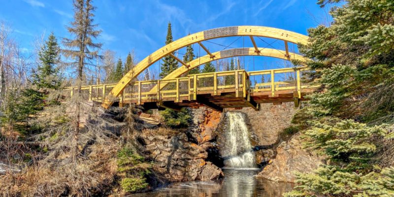
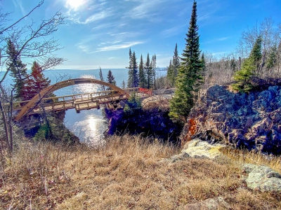 In 2021, the section of the Gitchi Gami State Trail between Cutface Creek and Grand Marais was completed. Part of this section includes a small wooden bridge that crosses over the Fall River. Just a few feet away from the bridge flow the Fall River Waterfall.
While this area has always been accessible by area trails and by Lake Superior, the addition of the Gitchi Gami State Trail made the area more accessible than ever before. The wide, paved trail allows for many more visitors to experience the beauty of the Fall River. Best accessed from Grand Marais, the trail can get rocky and the trail has several hilly areas. So while access may still be limiting to some, it has opened the experience up to many more.
Many local residents were dismayed by the addition of the bridge, which did change the scenery and landscape in the area, it was a welcome for many others who are now able to enjoy this beautiful waterfall when they couldn’t before. In an attempt to make the bridge more scenic, it was built primarily out of wood and includes two bump-out areas where picture-takers can be out of the way of passing bikers and hikers. The scenery of the area has definitely changed, but the bridge itself is pretty lovely to look at.
Fall River Waterfall? Or Rosebush Creek Waterfall?
 Another often contentious piece of trivia surrounding the Fall River Waterfall is the name of the waterfall itself. It appears as Fall River on most maps. The majority of articles you will read about this waterfall refer to is at as the Fall River Waterfall or Fall River Falls. However, if you go far enough back you will find that this waterfall had/has another name: the Rosebush Creek Waterfall.
Rosebush Creek and Fall River are two separate waterways that converge just 1,000 feet inland from the waterfall. Many who have lived in the area for a long time recall that the waterfall was once called the Rosebush Creek Waterfall. However, the primary source of water for the falls comes from the much larger Fall River. So, at some point, this section of the river was associated with the Fall River and the name of the waterfall changed.
Still, if you approach someone local asking for directions to the Fall River Waterfall, don’t be surprised to be greeted with “You mean the Rosebush Creek Falls?” They are one and the same, but to many, the name carries a different meaning. Just go with it.
Getting There
 Taking the Gitchi Gami State Trail is now the easiest way to access the Fall River Waterfall. You can reach the bridge from both Grand Marais and the Cutface Creek Wayside Rest. For accessible access from Grand Marais- park anywhere near “the top of the hill” in town where you can access the Gitchi Gami Trail on the lakeside of Highway 61. You should be able to get close to 1.5 miles out. Take the trail out of town until you reach the bridge.
Alternatively, you can park at the Cutface Creek Wayside Rest area just outside of Grand Marais. This section of the Gitchi Gami State Trail starts right behind the rest areas. You will be about 2.5 miles from the bridge coming from this side.
Many also park along Highway 61 just above the river near the overpass and hike down. Look for openings in the treeline near the highway overpass to make your way down alongside the river to the Gitchi Gami State Trail Bridge. This is not an accessible route, but the closest and fastest.